Climate and environment updates: 7 key measures of Earth's health in danger, report warns

More than 75% of the planet's health and life support systems are in danger.

Last Updated: October 6, 2025, 9:43 AM EDT

The climate crisis is not a distant threat; it's happening right now and affecting what matters most to us. Hurricanes intensified by a warming planet and drought-fueled wildfires are destroying our communities. Rising seas and flooding are swallowing our homes. And record-breaking heat waves are reshaping our way of life.

The good news is we know how to turn the tide and avoid the worst possible outcomes. However, understanding what needs to be done can be confusing due to a constant stream of climate updates, scientific findings and critical decisions that are shaping our future.

That's why the ABC News Climate and Weather Unit is cutting through the noise by curating what you need to know to keep the people and places you care about safe. We are dedicated to providing clarity amid the chaos, giving you the facts and insights necessary to navigate the climate realities of today -- and tomorrow.

Sep 17, 2025, 2:39 PM EDT

Wealthy households are more likely to flee hurricanes and flooding than other households: Study

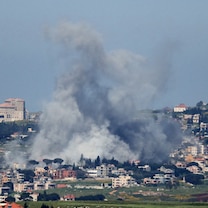
Extreme weather events can devastate communities. Now, a new study finds that it can also have long-term effects on a community's demographics that may hinder its ability to respond to future weather disasters.

The study from the University of Vermont, published in the journal Population and Environment, found that higher-income households left their communities at a higher rate than other households after hurricanes and damaging floods.

"Hurricanes had an impact on both net migration of people and net migration of income," said Mahalia Clark, lead author of the study.

The study examined anonymous IRS data from 2011 to 2021 to examine human migration and household income, and overlaid county-level data on weather-related property damage from data housed at Arizona State University.

"There hasn't been a ton of research that looks at how multiple different climate hazards affect human migration in the U.S.," said Clark. "There's even less on that migration's economic impacts."

In this Oct. 10, 2020, file photo, an aerial view of flood waters from Hurricane Delta is shown surrounding structures destroyed by Hurricane Laura, in Creole, Louisiana.
Mario Tama/Getty Images, FILE

Some regions experienced a different response to hurricanes and damaging flooding. The study found that the Northeast, for example, had fewer higher-income households leaving impacted communities.

"In the Northeast, we might be seeing those higher-income households being more responsive to this emerging threat," Clark said.

The study found that hurricanes had more of an impact on migration rates than other extreme weather events, but flooding had the highest impact on the income migration rates in affected areas.

"This suggests that you have either more higher-income households leaving, or fewer higher-income households arriving in those places," Clark said. "On average, the household income of the people leaving is higher than the average household income of people coming in."

-ABC News meteorologist Kyle David Reiman

Sep 15, 2025, 12:01 PM EDT

NOAA is using ocean robots to collect hurricane data

Forecasting hurricanes requires a lot of data. To predict when a hurricane will arrive, how strong it will be and where it's headed, meteorologists use sophisticated computer models that interpret measurements from the ocean and atmosphere.

Now, NOAA has another tool in its toolbox for collecting critical ocean information. In collaboration with the University of Southern Mississippi and robotics company Oshen, the agency has launched five small uncrewed surface vehicles.

The craft, called C-Stars, debuted on Aug. 31 by collecting critical weather and marine data off the coast of the U.S. Virgin Islands.

"Understanding weather conditions where the ocean surface meets the lower atmosphere is key to predicting hurricane intensity," said Greg Foltz, oceanographer and a lead principal investigator at NOAA's Atlantic Oceanographic and Meteorological Laboratory.

"If these miniature uncrewed surface vehicles prove reliable, they could become a critical piece of NOAA's hurricane observing system in the future," Foltz added.

NOAA is using a new robotic tool to collect hurricane data.
NOAA

The C-Stars are currently in a line extending from the U.S. Virgin Islands to Bermuda. The robots can be relocated to various oceanic regions to monitor different weather and marine conditions.

The C-Stars are wind-propelled with solar-powered sensors but are also equipped with electric motor thrusters for when the winds are weak.

The vehicles can operate individually or in fleets when covering a larger area. The C-Stars collect and transmit real-time data via satellite, including wind speed and direction, sea surface and air temperatures, air pressure and relative humidity.

"Although C-Stars have navigated storms with towering 24-foot waves, hurricanes are a whole new level of challenge -- but if it works, the long-term potential is huge," said Anahita Laverack, CEO for Oshen.

The C-Stars also collect wave condition information and can capture high-resolution images and videos, which can be retrieved when the craft returns to port.

"If these miniature uncrewed surface vehicles prove reliable, they could become a critical piece of NOAA's hurricane observing system in the future," Foltz added.

"We believe that these new, small USVs can move the needle in how we observe and understand hurricanes, while keeping budgets under control," Laverack added.

Lavarack told ABC News that the C-Stars are smaller, lighter, and cheaper to make and deploy than larger platforms, like the Saildrone that NOAA has used during previous hurricane seasons.

"Our size and platform cost allow us to field a constellation of many small robot C-Stars. In the future this could mean say 20 datapoints instead of just one within each hurricane, giving a richer understanding of the event," stated Laverack.

"We are excited by the role that C-Stars could play in improving hurricane forecasts, which have direct consequences for millions of people along the Gulf Coast," said Leila Hamdan, associate vice president for research and professor in the School of Ocean Science and Engineering at the University of Southern Mississippi.

-ABC News meteorologist Kyle David Reiman

Sep 09, 2025, 4:10 PM EDT

This summer was the 3rd-warmest on record for the Northern Hemisphere: Copernicus

The summer of 2025 (June to August) was the third-warmest on record for the Northern Hemisphere, surpassed only by the two previous ones in 2024 and 2023, according to new data analyzed by the Copernicus Climate Change Service (C3S).

Globally, last month also ranked as the third-warmest August on record, with an average surface air temperature of 61.88 degrees Fahrenheit.

While global air and sea surface temperatures are currently falling short of record highs, climate scientists warn this pause is unlikely to last as human-caused greenhouse gas emissions continue to fuel the long-term warming trend. Scientists anticipated a temporary decrease in global temperatures due to the recent La Niña event in the Pacific Ocean. This climate pattern usually results in a short-lived drop in global average temperatures.

People try to stay cool at the beach at Coney Island in Brooklyn as the region experiences another heatwave on July 30, 2025 in New York City.
Spencer Platt/Getty Images

The world's oceans remain warmer than average across the globe. Between the latitudes of 60 degrees south and 60 degrees north, the average global sea surface temperature was 69.48 degrees Fahrenheit, the third-highest value on record for August, according to Copernicus.

While the Atlantic Basin is currently quiet in terms of hurricane activity, unusually warm sea surface temperatures can play a key role in tropical cyclone development when more favorable atmospheric conditions return in the coming weeks.

In the polar regions, sea surface temperatures also frequently registered above average, negatively impacting sea ice. Antarctic sea ice coverage was 7% below average in August, ranking as the third-lowest value on record for the month. In the Arctic, it registered 12% below average, Copernicus said.

The Arctic region is warming much faster than the global average. After serving as a vital carbon sink for thousands of years, it has turned into a source of carbon dioxide emissions due to rapidly warming conditions and increasing wildfire activity, according to the National Oceanic and Atmospheric Administration.

-ABC News meteorologist Dan Peck

Sep 04, 2025, 10:47 AM EDT

Deforestation is making Amazon's dry-season drier: Study

The Amazon rainforest plays a vital role in regulating our climate and is one of the most biologically diverse ecosystems on Earth. But recent shifts in land use, vegetation and climate have disrupted the delicate balance between ecosystems and the atmosphere, significantly impacting the water, energy and carbon cycles of the rainforest. The full extent and long-term consequences of these disruptions, however, are not fully understood.

Now, for the first time, research led by scientists at the University of São Paulo in Brazil has identified the impacts of forest loss and human-amplified climate change on the Amazon.

To differentiate the regional effects of deforestation from the global impacts of climate change, researchers analyzed long-term atmospheric and land cover data from 29 sites across the Amazon, between 1985 and 2020.

The findings, published Tuesday in Nature Communications, show that deforestation accounted for a nearly 74% of the reduction in rainfall over the 35 years. It also accounted for 16.5% of the temperature increase during the Amazon's dry season. The researchers found global climate change was largely behind the warming trend.

Aerial view of an area of Amazon rainforest deforested by illegal fire in the municipality of Labrea, Amazonas State, Brazil, taken on August 20, 2024.
Evaristo Sa/AFP via Getty Images

Researchers focused their study on the dry season, as previous studies have shown that the regional climate effects of deforestation are more substantial and more consequential during this time. It's when the forest is most vulnerable to moisture deficits, and surface–atmosphere interactions become more pronounced.

The team warns that if deforestation remains unchecked, a further decline in total precipitation during the dry season and an even greater rise in temperature could occur. They say the findings underscore the importance of restoring and maintaining forest cover in the Amazon as a "crucial strategy for mitigating climate change and ensuring the stability of ecosystems."

In November, the government of Brazil, home of the Amazon, will host the 30th Conference of the Parties to the U.N. Framework Convention on Climate Change (COP30). Since the conference is being held in the Amazon, forests are expected to be a key topic of discussion.

"Forests can provide a crucial reprieve in the climate action agenda amidst a rapidly narrowing window of opportunity," COP30 President André Corrêa do Lago said in his inaugural official letter to the conference earlier this year.

-ABC News meteorologist Dan Peck

Sponsored Content by Taboola